Multi-Purpose Cash Response Expands Across Kenya’s Arid Counties
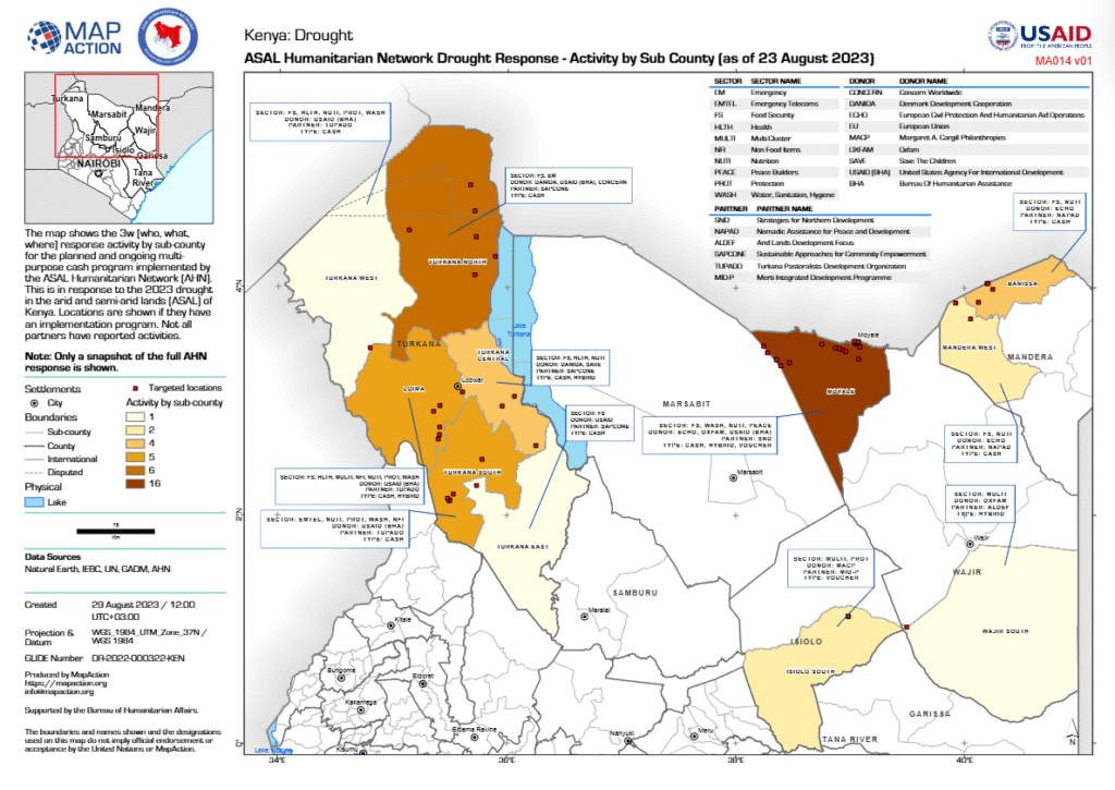
ASAL Humanitarian Network – Sub-County 3W Mapping 3W Overview – Sub-County Humanitarian Activity Snapshot The ASAL Humanitarian Network (AHN), in collaboration with MapAction, produced a sub-county level 3W (Who-What-Where) map detailing multi-purpose cash response activities implemented during the 2023 drought across Kenya’s arid and semi-arid counties. The visual captures the geographic spread of humanitarian interventions […]
Activity by Ward Highlights Kenya’s Multi-Agency Cash Assistance Coverage
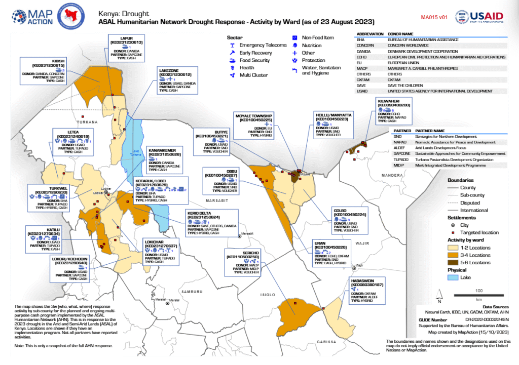
ASAL Humanitarian Network – Drought Response Mapping 3W Analysis – Who, What, Where in the 2023 Drought Response The ASAL Humanitarian Network (AHN), with technical support from MapAction, developed a 3W (Who-What-Where) drought response map illustrating ongoing and planned multi-purpose cash assistance across Kenya’s arid and semi-arid counties. The map, compiled as of 23 August […]
Mapping Kenya’s Arid and Semi-Arid Counties for Drought Response Coordination
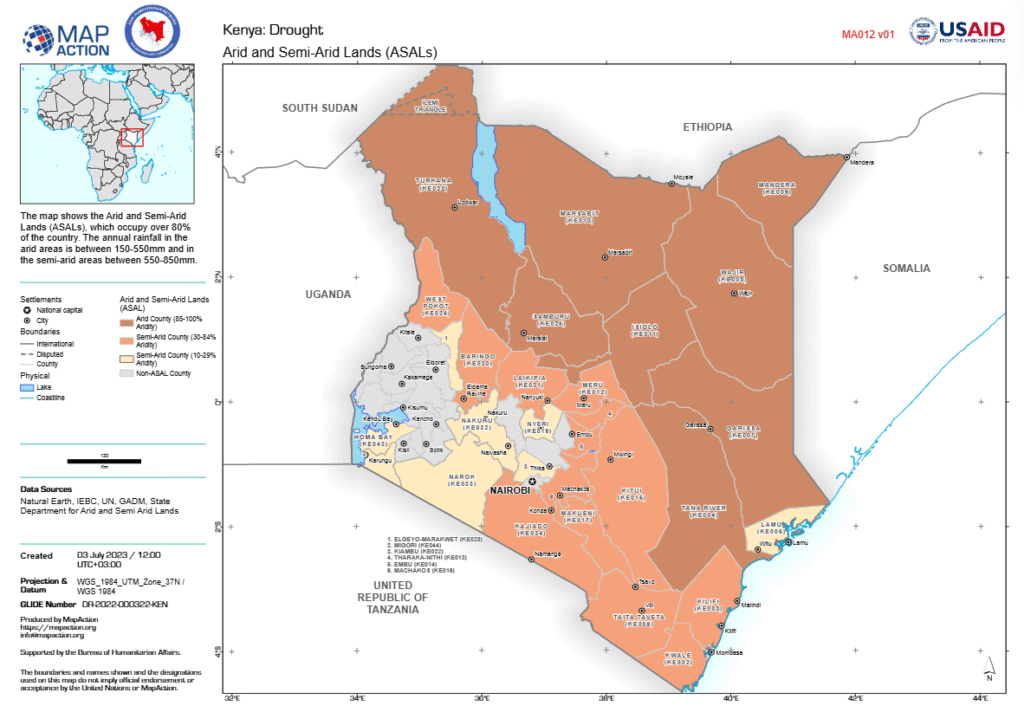
ASAL Humanitarian Network – Geographic Context Mapping Spatial Classification – Aridity Zones and Humanitarian Coverage This map, developed by MapAction in collaboration with the ASAL Humanitarian Network (AHN) and supported by the Bureau for Humanitarian Assistance (BHA), delineates Kenya’s Arid and Semi-Arid Lands (ASALs) based on data from the State Department for ASALs. The ASALs […]
5.4 Million People Projected to Face Acute Food Insecurity in Kenya’s ASALs
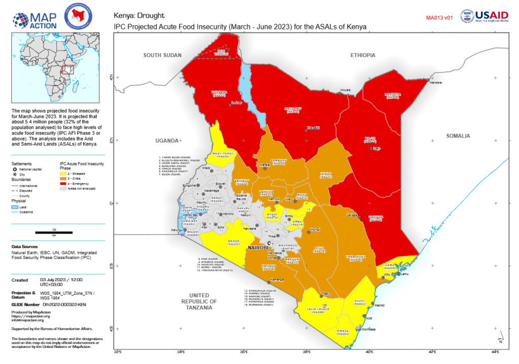
ASAL Humanitarian Network – Food Security Analysis IPC Projections – March to June 2023 The Integrated Food Security Phase Classification (IPC) analysis, visualized by MapAction with support from the ASAL Humanitarian Network (AHN) and the Bureau for Humanitarian Assistance (BHA), projects that 5.4 million people—equivalent to 32 percent of the population analyzed—will experience high levels […]
Population Density Insights Underpin Drought Response Targeting in Kenya
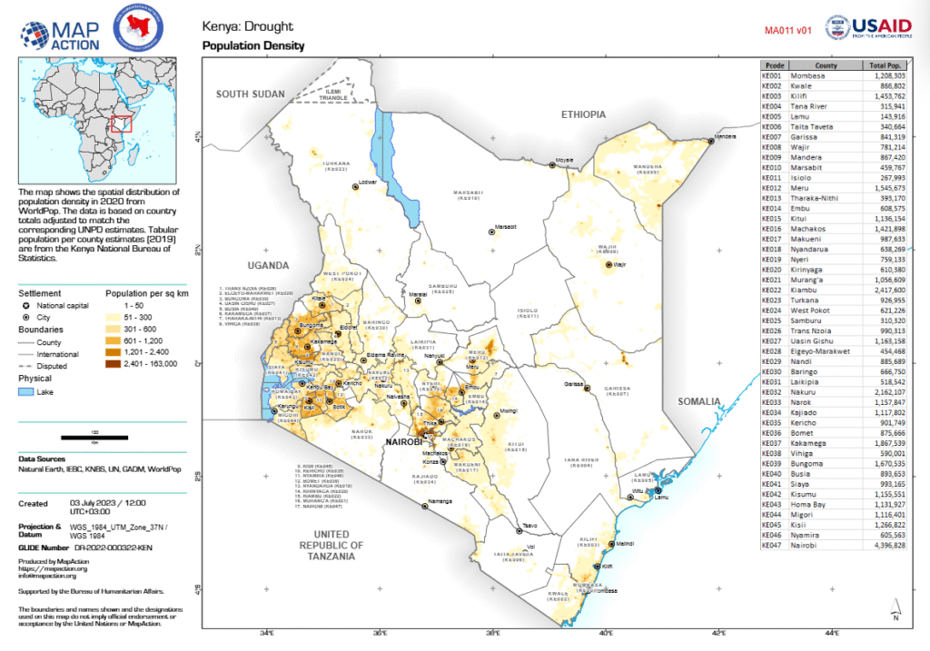
ASAL Humanitarian Network – Population & Vulnerability Mapping Spatial Analysis – Demographics and Humanitarian Planning The ASAL Humanitarian Network (AHN), in collaboration with MapAction, produced a sub-county level 3W (Who-What-Where) map detailing multi-purpose cash response activities implemented during the 2023 drought across Kenya’s arid and semi-arid counties. The visual captures the geographic spread of humanitarian […]
Mapping of Targeted Households and Villages for Cash Response in Marsabit County
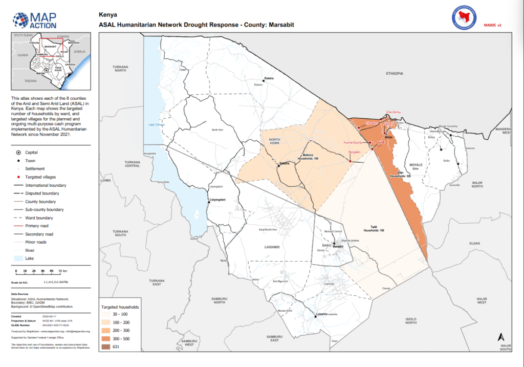
ASAL Humanitarian Network – County-Level Humanitarian Targeting Humanitarian Atlas – February 2022 This county-level humanitarian atlas, produced by MapAction in partnership with the ASAL Humanitarian Network (AHN), illustrates the geographic targeting of households and villages in Marsabit County under AHN’s multi-purpose cash transfer (MPCT) drought response initiated in November 2021. The map visualizes the number […]
Mapping Household Coverage for Multi-Purpose Cash Transfers in Turkana County
ASAL Humanitarian Network – County-Level Humanitarian Targeting Humanitarian Atlas – February 2022 This county-level humanitarian atlas, produced by MapAction in collaboration with the ASAL Humanitarian Network (AHN), visualizes the distribution of targeted households and villages in Turkana County as part of the multi-purpose cash transfer (MPCT) drought response launched in November 2021. The map displays […]
Mapping Targeted Households and Villages in Wajir County Drought Response
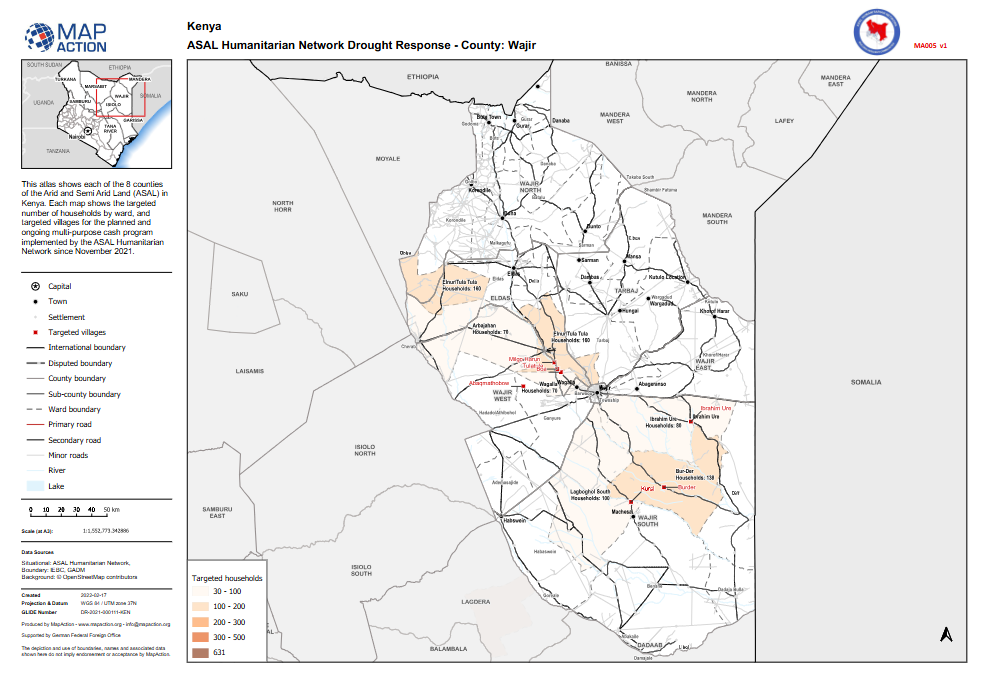
ASAL Humanitarian Network – County-Level Humanitarian Targeting Humanitarian Atlas – February 2022 This county-level humanitarian atlas, produced by MapAction in collaboration with the ASAL Humanitarian Network (AHN), presents the geographic targeting of households and villages in Wajir County under AHN’s multi-purpose cash transfer (MPCT) drought response programme launched in November 2021. The map illustrates the […]
Mapping Targeted Villages and Households for Cash Response in Tana River County
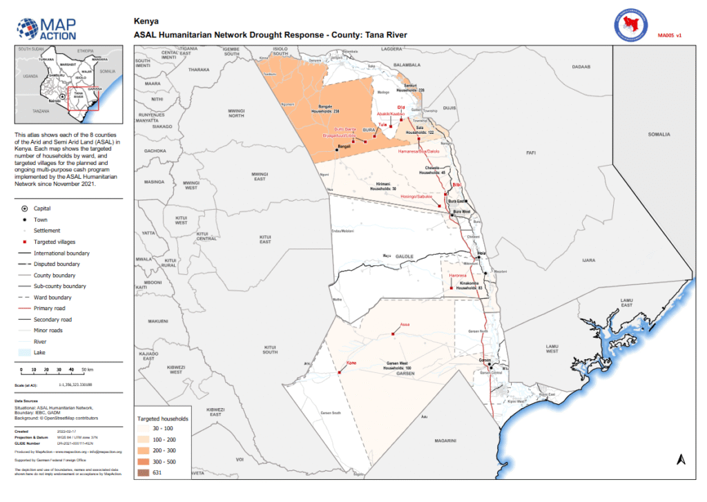
ASAL Humanitarian Network – County-Level Humanitarian Targeting Humanitarian Atlas – February 2022 This county-level humanitarian atlas, produced by MapAction in collaboration with the ASAL Humanitarian Network (AHN), provides a geographic overview of targeted households and villages in Tana River County under AHN’s multi-purpose cash transfer (MPCT) drought response initiated in November 2021. The map visualizes […]
Mapping Conflict Drivers Linked to Drought Conditions Across Kenya’s ASAL Counties
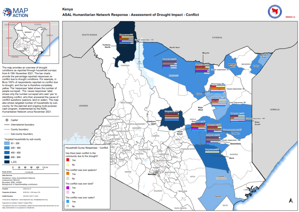
ASAL Humanitarian Network – Drought Impact Assessment Conflict Assessment Map – February 2022 This analytical map, produced by MapAction in collaboration with the ASAL Humanitarian Network (AHN) and REACH Initiative, visualizes household survey responses on conflict related to drought impacts across Kenya’s Arid and Semi-Arid Lands (ASALs). The assessment, conducted between 6 and 15 November […]