Mapping Targeted Villages and Households for Cash Response in Tana River County
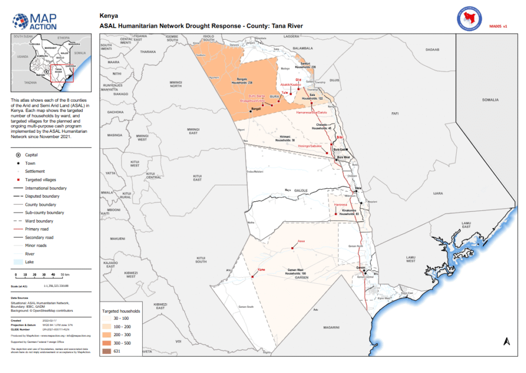
ASAL Humanitarian Network – County-Level Humanitarian Targeting Humanitarian Atlas – February 2022 This county-level humanitarian atlas, produced by MapAction in collaboration with the ASAL Humanitarian Network (AHN), provides a geographic overview of targeted households and villages in Tana River County under AHN’s multi-purpose cash transfer (MPCT) drought response initiated in November 2021. The map visualizes […]
Mapping Conflict Drivers Linked to Drought Conditions Across Kenya’s ASAL Counties
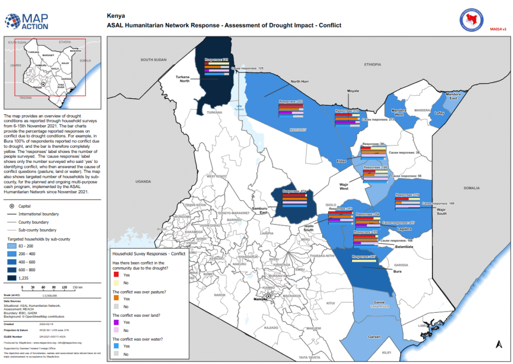
ASAL Humanitarian Network – Drought Impact Assessment Conflict Assessment Map – February 2022 This analytical map, produced by MapAction in collaboration with the ASAL Humanitarian Network (AHN) and REACH Initiative, visualizes household survey responses on conflict related to drought impacts across Kenya’s Arid and Semi-Arid Lands (ASALs). The assessment, conducted between 6 and 15 November […]
Geographic Mapping of Targeted Villages and Households in Samburu County
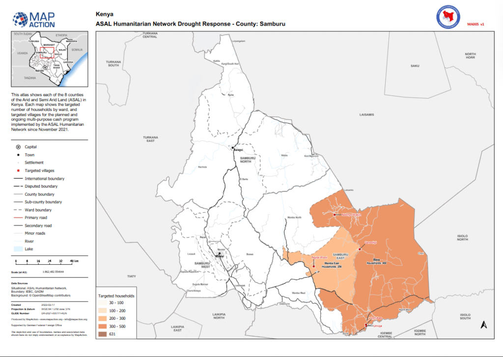
ASAL Humanitarian Network – County-Level Humanitarian Targeting Humanitarian Atlas – February 2022 This map, developed by MapAction in partnership with the ASAL Humanitarian Network (AHN), visualizes the distribution of targeted households and villages in Samburu County under AHN’s multi-purpose cash transfer (MPCT) drought response launched in November 2021. The atlas illustrates the spatial coverage of […]
Mapping the Scale and Distribution of Cash Transfers Across Kenya’s ASAL Counties
ASAL Humanitarian Network – Cash Transfer Landscape Humanitarian Cash Response Overview – February 2022 This map, produced by MapAction in partnership with the ASAL Humanitarian Network (AHN), visualizes the total value and distribution of multi-purpose cash transfers (MPCTs) across Kenya’s Arid and Semi-Arid Lands (ASALs) in response to the ongoing drought crisis. It shows the […]
Linking Humanitarian Targeting to Food Insecurity Phases Across Kenya’s ASAL Counties
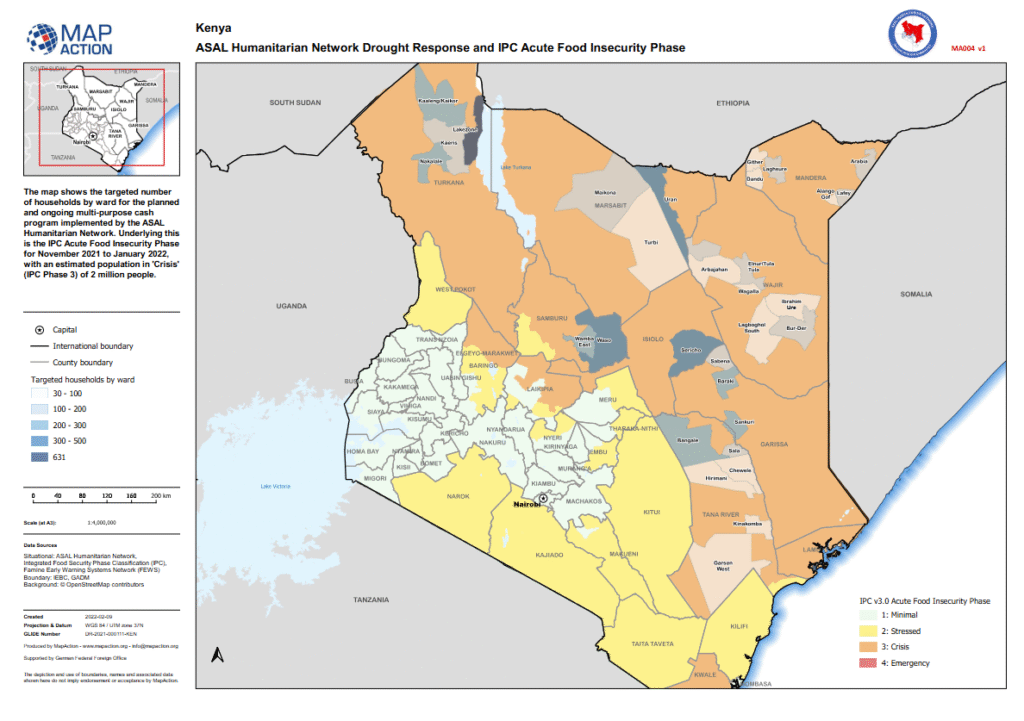
ASAL Humanitarian Network – Food Security Mapping Drought Response and IPC Mapping – February 2022 This analytical map, produced by MapAction in collaboration with the ASAL Humanitarian Network (AHN), integrates multi-purpose cash transfer (MPCT) targeting data with Integrated Food Security Phase Classification (IPC) analysis for the period November 2021 to January 2022. It provides a […]
Mapping Ward-Level Household Targeting Across Kenya’s Drought-Affected ASAL Counties
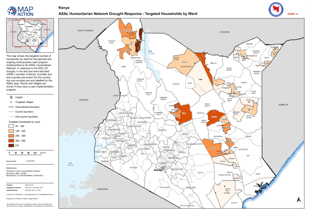
ASAL Humanitarian Network – Sub-County 3W Mapping Targeted Households by Ward – February 2022 This map, produced by MapAction in collaboration with the ASAL Humanitarian Network (AHN), illustrates the number of households targeted per ward under AHN’s multi-purpose cash transfer (MPCT) drought response for 2021–2022. It provides a geographic overview of programme coverage across Kenya’s […]
Mapping Drought Duration and Severity Across Kenya’s Arid and Semi-Arid Counties
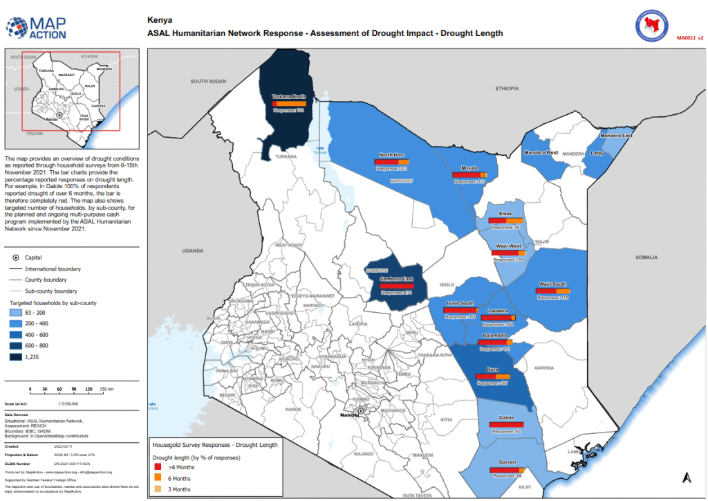
ASAL Humanitarian Network – Drought Impact Assessment Drought Length Overview – February 2022 This map, produced by MapAction in collaboration with the ASAL Humanitarian Network (AHN) and REACH Initiative, provides a spatial overview of drought duration and severity across Kenya’s Arid and Semi-Arid Lands (ASALs) based on household surveys conducted between 6 and 15 November […]
Mapping Drought Duration and Crop Losses Across Kenya’s ASAL Counties
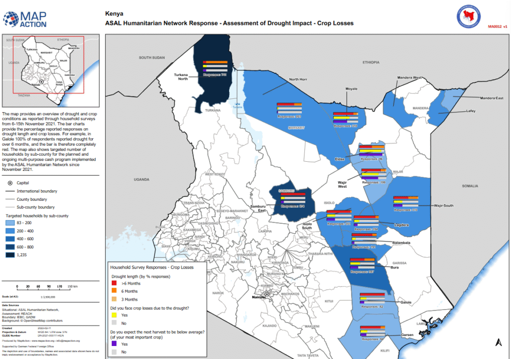
ASAL Humanitarian Network – Drought Impact Assessment Agricultural Impact Assessment – February 2022 This analytical map, produced by MapAction in collaboration with the ASAL Humanitarian Network (AHN) and REACH Initiative, visualizes drought duration, crop loss, and harvest expectations across Kenya’s Arid and Semi-Arid Lands (ASALs). The data is derived from household surveys conducted between 6 […]
Mapping Drought Duration, Rangeland Loss, and Livestock Condition Across Kenya’s ASALs
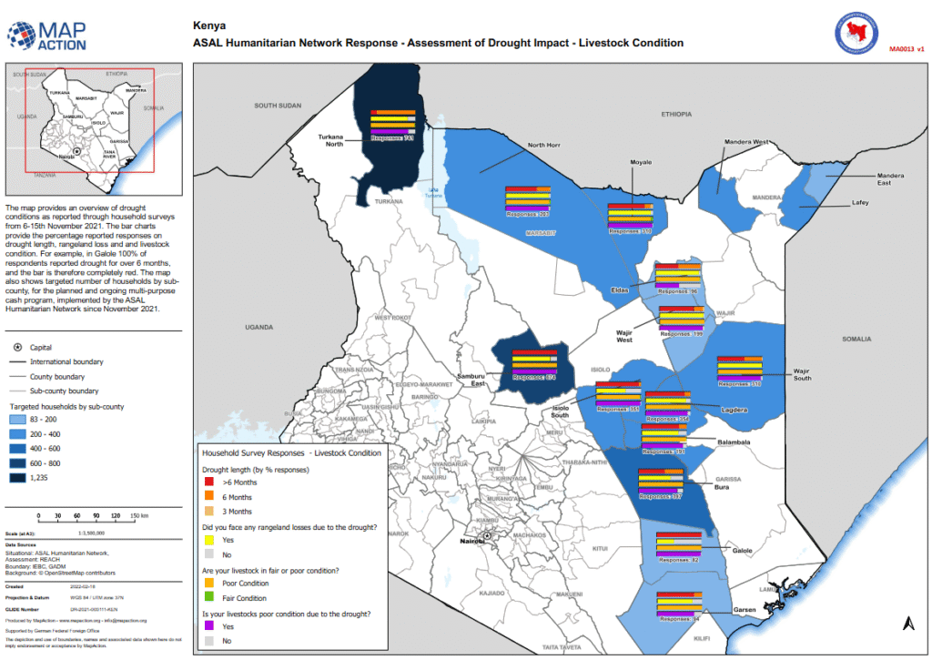
ASAL Humanitarian Network – Drought Impact Assessment Agricultural Impact Assessment – February 2022 This analytical map, developed by MapAction in collaboration with the ASAL Humanitarian Network (AHN) and REACH Initiative, visualizes household survey data on drought duration, rangeland degradation, and livestock condition across Kenya’s Arid and Semi-Arid Lands (ASALs). The survey was conducted between 6 […]
Mapping Targeted Households and Villages in Garissa County
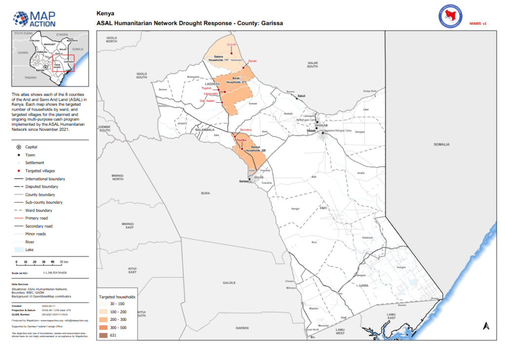
ASAL Humanitarian Network – County-Level Humanitarian Targeting Humanitarian Atlas – February 2022 This county-level map, produced by MapAction in collaboration with the ASAL Humanitarian Network (AHN), illustrates the geographic distribution of targeted households and villages in Garissa County under AHN’s multi-purpose cash transfer (MPCT) drought response launched in November 2021. The map displays ward-level targeting, […]